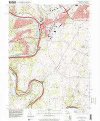
1997 Map of Williamsport
USGS Topo · Published 2000About this map
Williamsport serves as a focal point where the Conococheague Creek meets the Potomac River, highlighting a landscape defined by the historic path of the Chesapeake and Ohio Canal. By the late 1990s, the area reflects a complex layering of transportation history, from the canal's winding route and the Conrail tracks to the modern intersection of Interstate 81 and Interstate 70.
Find a feature on this map
77 named features on this map. Tap any name to fly to it.
Don’t see what you’re looking for? This feature index may not catch every label — zoom into the map to look around manually.
Map Details
Editions of this 1997 Williamsport Map
This is the sole edition of this map. No revisions or reprints were ever made.
Other maps of this area

1884 · Harpers Ferry
USGS Topo · 1:125,000

1891 · Harpers Ferry
USGS Topo · 1:125,000

1893 · Harpers Ferry
USGS Topo · 1:125,000

1908 · Middletown
USGS Topo · 1:48,000

1909 · Hagerstown
USGS Topo · 1:48,000

1910 · Antietam
USGS Topo · 1:62,500

1912 · Hagerstown
USGS Topo · 1:62,500

1912 · Williamsport
USGS Topo · 1:62,500

1914 · Martinsburg
USGS Topo · 1:48,000

1916 · Martinsburg
USGS Topo · 1:62,500