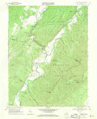
1969 Map of Williamsville
USGS Topo · Published 1971About this map
Williamsville sits at the junction of the Bullpasture River and the Cowpasture River, serving as a central hub in this 1969 topographic portrait of the Virginia highlands. The landscape is defined by the sharp relief of Bullpasture Mountain and Shenandoah Mountain, where narrow valleys host small settlements like Flood and Patna. Local history is anchored by community landmarks such as Mt Zion Ch and the Lockridge Memorial Ch, while the Coursey Springs Fish Hatchery indicates the area's reliance on its clear mountain waters.
Find a feature on this map
64 named features on this map. Tap any name to fly to it.
Don’t see what you’re looking for? This feature index may not catch every label — zoom into the map to look around manually.
Map Details
Editions of this 1969 Williamsville Map
3 editions found
Other maps of this area

1894 · Staunton
USGS Topo · 1:125,000

1901 · Monterey
USGS Topo · 1:125,000

1924 · Mc Dowell
USGS Topo · 1:62,500

1941 · Monterey
USGS Topo · 1:62,500

1943 · Craigsville
USGS Topo · 1:62,500

1944 · Monterey
USGS Topo · 1:62,500

1944 · Mc Dowell
USGS Topo · 1:62,500

1945 · Craigsville
USGS Topo · 1:62,500

1946 · Mc Dowell
USGS Topo · 1:62,500

1946 · Williamsville
USGS Topo · 1:62,500