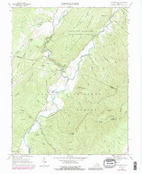
1969 Map of Williamsville
USGS Topo · Published 1988About this map
The Bullpasture River and Cowpasture River carve a distinctive drainage pattern through this corner of Bath and Highland Counties. In the late 1960s, the small settlement of Williamsville serves as a central point where the river emerges from the dramatic Bullpasture Gorge. To the south, the Coursey Springs State Fish Hatchery utilizes the region's natural spring systems, while the presence of Lockridge Memorial Ch and Mt Zion Ch indicates established rural communities. The map reflects a landscape deeply integrated with conservation and public land, bounded by the George Washington National Forest and the Highland Wildlife Management Area. Family-named peaks like Marshall Knob and Wallace Peak rise above numerous hollows and drafts, such as Scotchtown Draft and Jeremish Hollow, preserving the names of the early families who settled these narrow valleys.
Find a feature on this map
67 named features on this map. Tap any name to fly to it.
Don’t see what you’re looking for? This feature index may not catch every label — zoom into the map to look around manually.
Map Details
Editions of this 1969 Williamsville Map
3 editions found
Other maps of this area

1894 · Staunton
USGS Topo · 1:125,000

1901 · Monterey
USGS Topo · 1:125,000

1924 · Mc Dowell
USGS Topo · 1:62,500

1941 · Monterey
USGS Topo · 1:62,500

1943 · Craigsville
USGS Topo · 1:62,500

1944 · Monterey
USGS Topo · 1:62,500

1944 · Mc Dowell
USGS Topo · 1:62,500

1945 · Craigsville
USGS Topo · 1:62,500

1946 · Mc Dowell
USGS Topo · 1:62,500

1946 · Williamsville
USGS Topo · 1:62,500