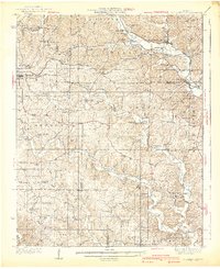
1940 Map of Williamsville
USGS Topo · Published 1940About this map
The Black River defines the rugged Ozark topography of Wayne County, winding past Williamsville and the St Louis San Francisco railway line. This 1940 edition captures a landscape of small, localized communities and isolated rural schools, including Cromerstown Sch and Lower Tenmile Sch. The transition between Wayne, Carter, Butler, and Ripley counties is marked by timber and early recreation, evidenced by the Fire Tower CCC Camp and the Keener Cave Resort. Families and genealogists can trace deep local roots through small burial grounds like Sparkman Cem and Kearney Cem. Industrial activity is represented by the Barrett Mine in the north and the settlement of Milltown on Hurricane Creek. These details reflect an era of tight-knit upland settlements and a river-based economy just before modern infrastructure reshaped the region.
Find a feature on this map
88 named features on this map. Tap any name to fly to it.
Don’t see what you’re looking for? This feature index may not catch every label — zoom into the map to look around manually.
Map Details
Editions of this 1940 Williamsville Map
2 editions found

Other maps of this area

1932 · Piedmont
USGS Topo · 1:62,500

1934 · Greenville
USGS Topo · 1:62,500

1934 · Williamsville
USGS Topo · 1:48,000

1935 · Poplar Bluff
USGS Topo · 1:62,500

1935 · Piedmont
USGS Topo · 1:62,500

1935 · Acorn
USGS Topo · 1:62,500

1935 · Harviell
USGS Topo · 1:62,500

1939 · Greenville
USGS Topo · 1:62,500

1939 · Poplar Bluff
USGS Topo · 1:62,500

1939 · Doniphan
USGS Topo · 1:62,500