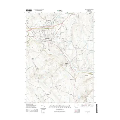
2015 Map of Willimantic
USGS Topo · Published 2015About this map
The Natchaug River and Willimantic River converge at the Crotch of the River to form the Shetucket River, a hydrological junction that historically powered the industrial development of Willimantic. This modern survey documents the urban layout of the city, including the Willimantic Footbridge and the campus of Eastern Connecticut State Univ, alongside the neighboring village of Conantville. Beyond the urban center, the landscape transitions into the hills and valleys of eastern Connecticut, where small settlements like South Windham, Williams Crossing, and North Franklin are connected by a network of winding roads and historical landmarks.
Find a feature on this map
187 named features on this map. Tap any name to fly to it.
Don’t see what you’re looking for? This feature index may not catch every label — zoom into the map to look around manually.
Map Details
Editions of this 2015 Willimantic Map
This is the sole edition of this map. No revisions or reprints were ever made.
Other maps of this area

1892 · Woodstock
USGS Topo · 1:62,500

1892 · Tolland
USGS Topo · 1:62,500

1892 · Norwich
USGS Topo · 1:62,500

1892 · Gilead
USGS Topo · 1:62,500

1921 · Tolland
USGS Topo · 1:62,500

1921 · Woodstock
USGS Topo · 1:62,500

1943 · Fitchville
USGS Topo · 1:31,680

1944 · South Coventry
USGS Topo · 1:31,680
1944 · Hampton
USGS Topo · 1:31,680

1944 · Columbia
USGS Topo · 1:31,680