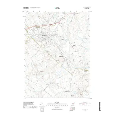
2018 Map of Willimantic
USGS Topo · Published 2018About this map
Willimantic serves as a central hub where the Willimantic River and Nachaug River converge at the Crotch of the River, a landscape defined by significant water resources and industrial heritage. The campus of Eastern Connecticut State Univ sits within the urban center, while the iconic Willimantic Footbridge spans the rail and river corridors that shaped the city's development. Surrounding the city, the topography rises into a series of notable summits, including Hosmer Mtn and Bush Hill, which overlook the transition from dense settlement to the more rural stretches of Windham and South Windham.
Find a feature on this map
80 named features on this map. Tap any name to fly to it.
Don’t see what you’re looking for? This feature index may not catch every label — zoom into the map to look around manually.
Map Details
Editions of this 2018 Willimantic Map
This is the sole edition of this map. No revisions or reprints were ever made.
Other maps of this area

1892 · Woodstock
USGS Topo · 1:62,500

1892 · Tolland
USGS Topo · 1:62,500

1892 · Norwich
USGS Topo · 1:62,500

1892 · Gilead
USGS Topo · 1:62,500

1921 · Tolland
USGS Topo · 1:62,500

1921 · Woodstock
USGS Topo · 1:62,500

1943 · Fitchville
USGS Topo · 1:31,680

1944 · South Coventry
USGS Topo · 1:31,680
1944 · Hampton
USGS Topo · 1:31,680

1944 · Columbia
USGS Topo · 1:31,680