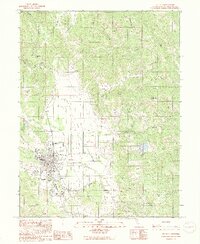
1991 Map of Willits
USGS Topo · Published 1991About this map
Little Lake Valley serves as the focal point of this Mendocino County landscape, where the city of Willits transitions from a dense grid into the surrounding hills. This 1991 provisional map captures the community during a period of infrastructure management, noting the Sewage Treatment facility and Radio Towers alongside traditional local landmarks like the Fairground. The northern reaches are defined by a complex drainage system including Outlet Creek and Berry Creek, while the settlement of Muir sits to the south. Land use in the valley is varied, featuring the Ells-Willits Airport and a prominent Gravel Pit. The surrounding topography is marked by significant elevations such as Big Darby Peak and Tenney Peak, illustrating the contrast between the flat alluvial floor and the steep ridges of the California Coast Ranges.
Find a feature on this map
49 named features on this map. Tap any name to fly to it.
Don’t see what you’re looking for? This feature index may not catch every label — zoom into the map to look around manually.
Map Details
Editions of this 1991 Willits Map
2 editions found
Other maps of this area

1922 · Willits
USGS Topo · 1:62,500

1929 · Eden Valley
USGS Topo · 1:62,500

1942 · Willits
USGS Topo · 1:62,500

1943 · Pomo
USGS Topo · 1:62,500

1944 · Willits
USGS Topo · 1:62,500

1951 · Laytonville
USGS Topo · 1:62,500

1952 · Eden Valley
USGS Topo · 1:62,500

1957 · Ukiah
USGS Topo · 1:250,000

1960 · Ukiah
USGS Topo · 1:250,000

1960 · Potter Valley
USGS Topo · 1:62,500