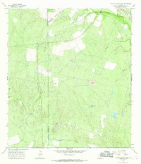
1965 Map of Willow Hollow Tank
USGS Topo · Published 1968About this map
The Jacob Oil Field dominates the western landscape of this mid-1960s survey, marking a period of active resource extraction along the border of McMullen and Live Oak counties. Numerous Oil Wells and a Drill Hole are scattered across the terrain, illustrating the industrial footprint on the South Texas brush country. While the western half focuses on petroleum, the eastern portion is defined by drainage patterns and livestock water sources, most notably the Willow Hollow Tank.
Find a feature on this map
19 named features on this map. Tap any name to fly to it.
Don’t see what you’re looking for? This feature index may not catch every label — zoom into the map to look around manually.
Map Details
Editions of this 1965 Willow Hollow Tank Map
This is the sole edition of this map. No revisions or reprints were ever made.
Other maps of this area

1920 · Mikeska
USGS Topo · 1:125,000

1925 · Simmons No. 1
USGS Topo · 1:48,000

1925 · Crowther No. 3
USGS Topo · 1:48,000

1925 · Simmons No. 2
USGS Topo · 1:48,000

1927 · Oakville
USGS Topo · 1:62,500

1929 · Simmons
USGS Topo · 1:62,500

1930 · Whitsett
USGS Topo · 1:62,500

1942 · Whitsett
USGS Topo · 1:62,500

1953 · Crystal City
USGS Topo · 1:250,000

1955 · Crystal City
USGS Topo · 1:250,000