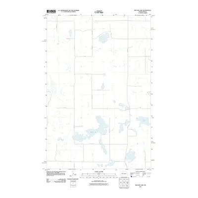
2011 Map of Willow Lake
USGS Topo · Published 2011About this map
Willow Lake and Swan Lake dominate this prairie landscape in North Dakota, where the water table and natural topography create an intricate network of wetlands and seasonal potholes. This 2011 survey by the U.S. Geological Survey illustrates a sparse rural environment organized by a rigid section-line road grid, including 32nd Ave SE and 10th St Se. The terrain is characterized by these interior drainage basins typical of the region's glacial history. Apart from the primary arterial County Rd 4, the map reveals a quiet landscape of small water bodies and section roads such as 4th St Se and 35th Ave SE. The lack of named settlements or heavy industry highlights the preservation of a purely agricultural and hydrologic character in this part of Kidder County.
Find a feature on this map
17 named features on this map. Tap any name to fly to it.
Don’t see what you’re looking for? This feature index may not catch every label — zoom into the map to look around manually.
Map Details
Editions of this 2011 Willow Lake Map
This is the sole edition of this map. No revisions or reprints were ever made.
Other maps of this area

1951 · Bowdon
USGS Topo · 1:24,000

1952 · New Rockford
USGS Topo · 1:250,000

1956 · New Rockford
USGS Topo · 1:250,000

1971 · New Rockford
USGS Topo · 1:250,000

1972 · Tuttle
USGS Topo · 1:24,000

1972 · Robinson
USGS Topo · 1:24,000

1972 · Des Moines Lake
USGS Topo · 1:24,000

1978 · Wagon Wheel Hill
USGS Topo · 1:24,000
1978 · Willow Lake
USGS Topo · 1:24,000
1978 · Senior Lake
USGS Topo · 1:24,000