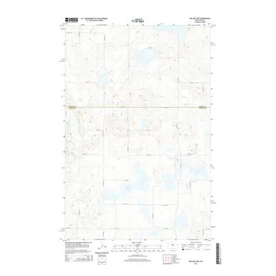
2014 Map of Willow Lake
USGS Topo · Published 2014About this map
Willow Lake and Swan Lake dominate the landscape of this prairie region where the border of Wells Co and Kidder Co meets. The terrain is defined by glacial potholes and wetland basins, a hallmark of the Missouri Coteau. A rigid grid of section-line roads, including Cr-4 and various numbered avenues like 32nd Ave SE and 33rd Ave SE, cuts through the undulating topography, reflecting the enduring legacy of the Public Land Survey System. While no primary settlements are named on this quadrangle, the dense network of local roads such as 6th St SE and 11th St SE provides access to the isolated farmsteads that characterize this rural North Dakota interior.
Find a feature on this map
21 named features on this map. Tap any name to fly to it.
Don’t see what you’re looking for? This feature index may not catch every label — zoom into the map to look around manually.
Map Details
Editions of this 2014 Willow Lake Map
This is the sole edition of this map. No revisions or reprints were ever made.
Other maps of this area

1951 · Bowdon
USGS Topo · 1:24,000

1952 · New Rockford
USGS Topo · 1:250,000

1956 · New Rockford
USGS Topo · 1:250,000

1971 · New Rockford
USGS Topo · 1:250,000

1972 · Tuttle
USGS Topo · 1:24,000

1972 · Robinson
USGS Topo · 1:24,000

1972 · Des Moines Lake
USGS Topo · 1:24,000

1978 · Wagon Wheel Hill
USGS Topo · 1:24,000
1978 · Willow Lake
USGS Topo · 1:24,000
1978 · Senior Lake
USGS Topo · 1:24,000