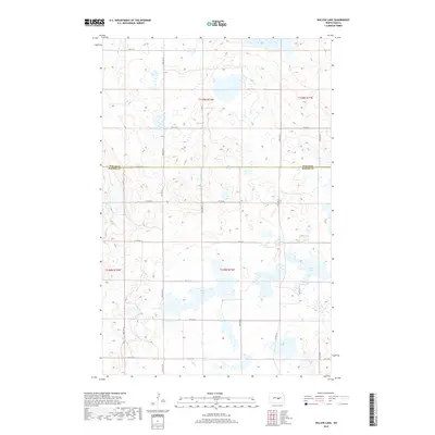
2018 Map of Willow Lake
USGS Topo · Published 2018About this map
Willow Lake and Swan Lake anchor this prairie landscape, reflecting the glacial pothole geography of central North Dakota. The area is defined by the Wells Co Kidder Co boundary line, which divides a sparse grid of rural townships. The layout is primarily agricultural, dominated by a network of sectional roads such as 33rd Ave SE and 7th St SE.
Find a feature on this map
24 named features on this map. Tap any name to fly to it.
Don’t see what you’re looking for? This feature index may not catch every label — zoom into the map to look around manually.
Map Details
Editions of this 2018 Willow Lake Map
This is the sole edition of this map. No revisions or reprints were ever made.
Other maps of this area

1951 · Bowdon
USGS Topo · 1:24,000

1952 · New Rockford
USGS Topo · 1:250,000

1956 · New Rockford
USGS Topo · 1:250,000

1971 · New Rockford
USGS Topo · 1:250,000

1972 · Tuttle
USGS Topo · 1:24,000

1972 · Robinson
USGS Topo · 1:24,000

1972 · Des Moines Lake
USGS Topo · 1:24,000

1978 · Wagon Wheel Hill
USGS Topo · 1:24,000
1978 · Willow Lake
USGS Topo · 1:24,000
1978 · Senior Lake
USGS Topo · 1:24,000