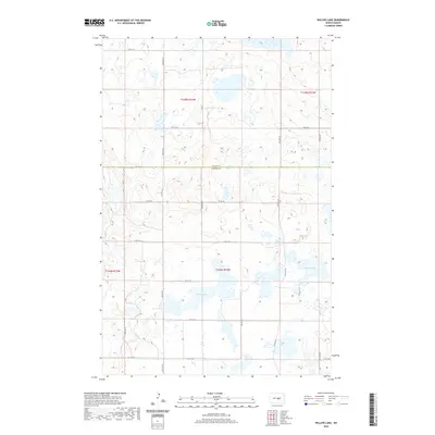
2020 Map of Willow Lake
USGS Topo · Published 2020About this map
Willow Lake and Swan Lake dominate the southern half of this prairie landscape, where the border between Wells Co and Kidder Co bisects the terrain. This is a region defined by its hydrology and section-line road system, including North Dakota's characteristic grid of routes like 30th Ave SE and 11th St SE. The map captures a moment in the early 21st century when the area remains primarily dedicated to agriculture and natural prairie wetlands. Local transportation is facilitated by thoroughfares such as Co Rd 4, which serves as a central artery through these rural townships. The absence of concentrated town centers emphasizes the vast, open nature of this part of the Central Flyway, where numerous smaller unnamed wetlands pepper the landscape around the two primary named lakes.
Find a feature on this map
24 named features on this map. Tap any name to fly to it.
Don’t see what you’re looking for? This feature index may not catch every label — zoom into the map to look around manually.
Map Details
Editions of this 2020 Willow Lake Map
This is the sole edition of this map. No revisions or reprints were ever made.
Other maps of this area

1951 · Bowdon
USGS Topo · 1:24,000

1952 · New Rockford
USGS Topo · 1:250,000

1956 · New Rockford
USGS Topo · 1:250,000

1971 · New Rockford
USGS Topo · 1:250,000

1972 · Tuttle
USGS Topo · 1:24,000

1972 · Robinson
USGS Topo · 1:24,000

1972 · Des Moines Lake
USGS Topo · 1:24,000

1978 · Wagon Wheel Hill
USGS Topo · 1:24,000
1978 · Willow Lake
USGS Topo · 1:24,000
1978 · Senior Lake
USGS Topo · 1:24,000