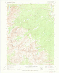
1970 Map of Willow Lakes
USGS Topo · Published 1973About this map
The high peaks of the Gore Range dominate this 1970s survey, straddling the boundary between the Arapaho National Forest and the White River National Forest. This high-altitude wilderness is characterized by a series of glacial basins holding prominent water bodies like Willow Lakes, Slate Lake, and Boulder Lake. Evidence of early mining efforts appears on the slopes of the Harrigan Range and near Keller Mountain, most notably at the Boss Mine and various nearby prospects.
Find a feature on this map
41 named features on this map. Tap any name to fly to it.
Don’t see what you’re looking for? This feature index may not catch every label — zoom into the map to look around manually.
Map Details
Editions of this 1970 Willow Lakes Map
4 editions found
Other maps of this area

1929 · Dillon
USGS Topo · 1:62,500

1933 · Mt. Powell
USGS Topo · 1:48,000

1933 · Ute Peak
USGS Topo · 1:62,500

1934 · Minturn
USGS Topo · 1:62,500

1934 · Dillon
USGS Topo · 1:62,500

1937 · Ute Peak
USGS Topo · 1:62,500

1940 · Mount Powell
USGS Topo · 1:62,500

1950 · Minturn
USGS Topo · 1:62,500

1957 · Leadville
USGS Topo · 1:250,000

1959 · Leadville
USGS Topo · 1:250,000