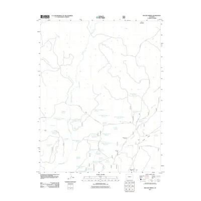
2011 Map of Willow Spring
USGS Topo · Published 2011About this map
Belmear Mountain rises above a high-country landscape defined by an extensive network of water management and resource extraction in Montezuma County. This 2011 survey reveals dozens of named catchments, ranging from the Upper Little Beaver Reservoir to the California Reservoir, illustrating the intensive irrigation and storage infrastructure required in this part of Colorado. The map documents industrial history at the North Star Mine and commemorates local heritage at Beaver Creek Massacre, a site positioned near the confluence of Beaver Creek and Long Draw.
Find a feature on this map
52 named features on this map. Tap any name to fly to it.
Don’t see what you’re looking for? This feature index may not catch every label — zoom into the map to look around manually.
Map Details
Editions of this 2011 Willow Spring Map
This is the sole edition of this map. No revisions or reprints were ever made.
Other maps of this area

1956 · Cortez
USGS Topo · 1:250,000

1958 · Cortez
USGS Topo · 1:250,000

1959 · Cortez
USGS Topo · 1:250,000

1962 · Cortez
USGS Topo · 1:250,000

1963 · Stoner
USGS Topo · 1:24,000
1963 · Nipple Mountain
USGS Topo · 1:24,000
1964 · Groundhog Reservoir
USGS Topo · 1:24,000

1964 · Glade Mountain
USGS Topo · 1:24,000
1964 · South Mountain
USGS Topo · 1:24,000

1965 · Willow Spring
USGS Topo · 1:24,000