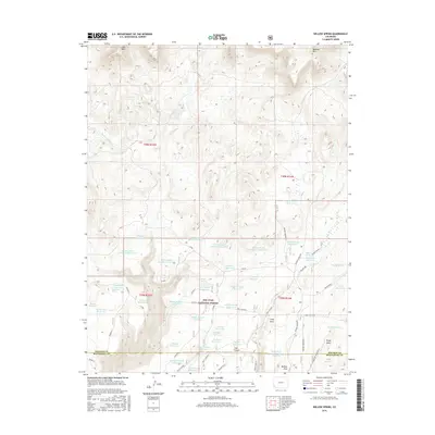
2016 Map of Willow Spring
USGS Topo · Published 2016About this map
San Juan National Forest lands cover this portion of the Colorado high country, where the landscape is defined by an intricate network of water management features and rugged canyon topography. Dozens of small-scale impoundments like Willow Spring Reservoir and Old Station Reservoir underscore the critical role of water storage in this arid environment. The terrain is marked by prominent elevations including Lone Mesa in the northwest and Belmear Mtn in the northeast, falling away into the deep cuts of Trail Canyon and Rocky Draw. The map documents a complex system of fire roads and trails, such as Trail Canyon A and Glade, which provide access through the forest. Named water sources like Rusty Spring and Willow Spring hint at the historical reliance on reliable groundwater for cattle or travelers along the county boundary between Dolores and Montezuma.
Find a feature on this map
55 named features on this map. Tap any name to fly to it.
Don’t see what you’re looking for? This feature index may not catch every label — zoom into the map to look around manually.
Map Details
Editions of this 2016 Willow Spring Map
This is the sole edition of this map. No revisions or reprints were ever made.
Other maps of this area

1956 · Cortez
USGS Topo · 1:250,000

1958 · Cortez
USGS Topo · 1:250,000

1959 · Cortez
USGS Topo · 1:250,000

1962 · Cortez
USGS Topo · 1:250,000

1963 · Stoner
USGS Topo · 1:24,000
1963 · Nipple Mountain
USGS Topo · 1:24,000
1964 · Groundhog Reservoir
USGS Topo · 1:24,000

1964 · Glade Mountain
USGS Topo · 1:24,000
1964 · South Mountain
USGS Topo · 1:24,000

1965 · Willow Spring
USGS Topo · 1:24,000