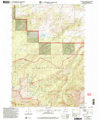
2000 Map of Willow Swamp
USGS Topo · Published 2005About this map
The Lee Metcalf Wilderness defines this high-country landscape in the Madison Range, where the Spanish Peaks and the Newell Creek Basin dominate the terrain. This alpine environment is characterized by an extensive network of headwater streams and glacial lakes, including the fraternal cluster of Big Brother Lake, Little Brother Lake, and Little Sister Lake. The map details a complex hydrologic system feeding into Spanish Creek and Cherry Creek, with prominent vertical features like Pioneer Falls and the secluded Lake Solitude.
Find a feature on this map
34 named features on this map. Tap any name to fly to it.
Don’t see what you’re looking for? This feature index may not catch every label — zoom into the map to look around manually.
Map Details
Editions of this 2000 Willow Swamp Map
This is the sole edition of this map. No revisions or reprints were ever made.
Other maps of this area

1888 · Three Forks
USGS Topo · 1:250,000

1894 · Three Forks
USGS Topo · 1:250,000

1895 · Three Forks
USGS Topo · 1:250,000

1947 · Bozeman
USGS Topo · 1:250,000

1948 · Bozeman
USGS Topo · 1:250,000

1949 · Anceney
USGS Topo · 1:62,500

1949 · Ennis
USGS Topo · 1:62,500

1949 · Norris
USGS Topo · 1:62,500

1950 · Spanish Peaks
USGS Topo · 1:62,500

1951 · Norris
USGS Topo · 1:62,500