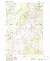
1987 Map of Willowcreek
USGS Topo · Published 1988About this map
Willowdale sits at the heart of this high-desert landscape, where the administrative boundary between Wasco Co and Jefferson Co cuts across a complex network of drainages and volcanic formations. The terrain is defined by its deep incisions, from the steep walls of Cow Canyon and Deadman Canyon in the north to the broad sweep of Trout Creek and Pony Creek further south. The presence of the Deschutes River Recreation Lands along the western margin indicates the early integration of public land management and conservation in this part of Oregon.
Find a feature on this map
24 named features on this map. Tap any name to fly to it.
Don’t see what you’re looking for? This feature index may not catch every label — zoom into the map to look around manually.
Map Details
Editions of this 1987 Willowcreek Map
This is the sole edition of this map. No revisions or reprints were ever made.
Other maps of this area

1906 · Mitchell Butte
USGS Topo · 1:125,000

1950 · Jamieson
USGS Topo · 1:62,500

1951 · Moores Hollow
USGS Topo · 1:62,500

1955 · Baker
USGS Topo · 1:250,000

1955 · Boise
USGS Topo · 1:250,000

1958 · Boise
USGS Topo · 1:250,000

1959 · Baker
USGS Topo · 1:250,000

1962 · Boise
USGS Topo · 1:250,000
1967 · Vale East
USGS Topo · 1:24,000
1967 · Vines Hill
USGS Topo · 1:24,000