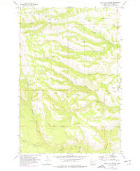
1957 Map of Willy Dick Canyon
USGS Topo · Published 1977About this map
Willy Dick Crossing marks a key passage point in this upland landscape of south-central Washington during the mid-20th century. The terrain is defined by dramatic geological features such as the Kah Mah Singh Ridge and Quin Sins Ridge, which separate deep drainages including Woodchoppers Canyon and Stamill Canyon. This area within the Yakima Indian Reservation shows a network of resource-related locations like Wild Horse Corral and the high pastures of Stamill Flat. The drainage pattern is complex, with Toppenish Creek joined by tributaries like Clock Creek and Branch Fork Creek. Vital water sources for the region's ranching or transit are noted at Fairview Spring and Lone Pine Spring. The placement of the Fort Simcoe Road underscores the historic importance of the route through Agency Creek, connecting the interior to established outposts.
Find a feature on this map
24 named features on this map. Tap any name to fly to it.
Don’t see what you’re looking for? This feature index may not catch every label — zoom into the map to look around manually.
Map Details
Editions of this 1957 Willy Dick Canyon Map
This is the sole edition of this map. No revisions or reprints were ever made.
Other maps of this area

1904 · Mount Adams
USGS Topo · 1:125,000

1907 · Mount Adams
USGS Topo · 1:125,000

1937 · White Swan
USGS Topo · 1:125,000

1950 · Yakima
USGS Topo · 1:250,000

1957 · Yesmowit Canyon
USGS Topo · 1:24,000

1958 · Fort Simcoe
USGS Topo · 1:24,000

1958 · Fort Simcoe
USGS Topo · 1:62,500
1958 · Medicine Valley
USGS Topo · 1:24,000

1958 · Yakima
USGS Topo · 1:250,000

1961 · Yakima
USGS Topo · 1:250,000