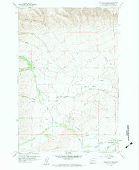
1958 Map of Medicine Valley
USGS Topo · Published 1960About this map
Medicine Valley is defined by a network of drainage systems and rural transit routes in central Washington. Simcoe Creek and Medicine Creek serve as the primary hydrologic arteries, fed by a series of high-altitude canyons including Poison Canyon, Whitefoot Canyon, and Hog Canyon. The landscape shows a mix of topographic transition and infrastructure development from the late 1950s, with several unimproved paths such as the Jeep Trail and Piscoe Meadows Road providing access to the higher elevations.
Find a feature on this map
30 named features on this map. Tap any name to fly to it.
Don’t see what you’re looking for? This feature index may not catch every label — zoom into the map to look around manually.
Map Details
Editions of this 1958 Medicine Valley Map
3 editions found
Other maps of this area

1899 · Ellensburg
USGS Topo · 1:125,000

1901 · Ellensburg
USGS Topo · 1:125,000

1937 · White Swan
USGS Topo · 1:125,000

1950 · Yakima
USGS Topo · 1:250,000

1957 · Yesmowit Canyon
USGS Topo · 1:24,000
1957 · Willy Dick Canyon
USGS Topo · 1:24,000

1958 · Toppenish Mtn.
USGS Topo · 1:24,000

1958 · Fort Simcoe
USGS Topo · 1:24,000

1958 · Fort Simcoe
USGS Topo · 1:62,500

1958 · Wiley City
USGS Topo · 1:24,000