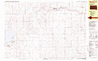
1982 Map of Wilmarth Lake
USGS Topo · Published 1983About this map
Wilmarth Lake and the surrounding wetlands of Aurora County characterize this 1982 survey, which highlights the region’s focus on conservation and water management. The landscape is defined by the headwaters of Firesteel Creek and its West Branch, feeding a series of significant lakes and sloughs. Large tracts of land are designated for conservation, including the Wilmarth Lake State Game Production Area and the National Waterfowl Production Area, reflecting the area's importance to migratory bird habitats in the Central Flyway. Smaller features such as Sportsman Park and various Gravel Pits indicate local land use amidst the sectioned agricultural townships. Notable terrain landmarks like Archer Hill rise above the basin of White Lake, providing a clear record of the glacial topography and water distribution in the central South Dakota plains during the late twentieth century.
Find a feature on this map
23 named features on this map. Tap any name to fly to it.
Don’t see what you’re looking for? This feature index may not catch every label — zoom into the map to look around manually.
Map Details
Editions of this 1982 Wilmarth Lake Map
This is the sole edition of this map. No revisions or reprints were ever made.
Other maps of this area

1899 · Mitchell
USGS Topo · 1:125,000

1941 · Kimball North
USGS Topo · 1:62,500

1942 · Crow Lake
USGS Topo · 1:62,500

1951 · Kimball North
USGS Topo · 1:62,500

1955 · Mitchell
USGS Topo · 1:250,000

1959 · Mitchell
USGS Topo · 1:250,000
1979 · Fraser Dam
USGS Topo · 1:24,000

1979 · Crystal Lake
USGS Topo · 1:24,000

1979 · White Lake
USGS Topo · 1:24,000

1979 · Platte Lake
USGS Topo · 1:24,000
Featured Places
- Eureka Township, SD
- White Lake Township, SD
- Pleasant Valley Township, SD
- Lake Township, SD
- Firesteel Township, SD