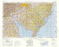
1955 Map of Wilmington
USGS Topo · Published 1955About this map
Philadelphia and Wilmington anchor this mid-century portrait of the Delaware Valley, showing a region defined by its industrial riverfronts and emerging modern transportation networks. The Delaware River serves as the central artery, flanked by rail infrastructure including the Pennsylvania Railroad and the Reading Railway System. At this date, the landscape reflects the rapid postwar growth of the South Jersey suburbs, with the recently completed New Jersey Turnpike and Garden State Parkway cutting through the coastal plains toward the shore.
Find a feature on this map
75 named features on this map. Tap any name to fly to it.
Don’t see what you’re looking for? This feature index may not catch every label — zoom into the map to look around manually.
Map Details
Editions of this 1955 Wilmington Map
This is the sole edition of this map. No revisions or reprints were ever made.
Other maps of this area

1884 · Sea Isle
USGS Topo · 1:62,500

1884 · Whitings
USGS Topo · 1:62,500

1887 · Atlantic City
USGS Topo · 1:62,500

1888 · Bordentown
USGS Topo · 1:62,500

1888 · Pemberton
USGS Topo · 1:62,500

1888 · Barnegat
USGS Topo · 1:62,500

1888 · Cape May
USGS Topo · 1:62,500

1888 · Dennisville
USGS Topo · 1:62,500

1888 · Little Egg Harbor
USGS Topo · 1:62,500

1888 · Mount Holly
USGS Topo · 1:62,500