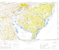
1959 Map of Wilmington
USGS Topo · Published 1959About this map
Philadelphia, Camden, and Wilmington form the industrial heart of this mid-century landscape, connected by a dense network of Pennsylvania and Reading rail lines. The Delaware River serves as the primary artery for trade and navigation, passing the Del Mem Bridge (toll) before widening into the expansive Delaware Bay. Along the southern New Jersey coast, the map details the barrier island system from Atlantic City north toward Island Beach, including several inlets like Absecon Inlet and Great Egg Inlet. Further inland, the vast pine forests are punctuated by established settlements like Vineland and the sprawling Fort Dix Military Reservation. This survey captures the region's transport patterns before the full maturation of the interstate system, highlighting the 중요성 of maritime landmarks such as the Ship John Shoal Light and Miah Maull Shoal Lighthouse for guiding bay traffic.
Find a feature on this map
162 named features on this map. Tap any name to fly to it.
Don’t see what you’re looking for? This feature index may not catch every label — zoom into the map to look around manually.
Map Details
Editions of this 1959 Wilmington Map
3 editions found
Other maps of this area

1884 · Sea Isle
USGS Topo · 1:62,500

1884 · Whitings
USGS Topo · 1:62,500

1887 · Atlantic City
USGS Topo · 1:62,500

1888 · Bordentown
USGS Topo · 1:62,500

1888 · Pemberton
USGS Topo · 1:62,500

1888 · Barnegat
USGS Topo · 1:62,500

1888 · Cape May
USGS Topo · 1:62,500

1888 · Dennisville
USGS Topo · 1:62,500

1888 · Little Egg Harbor
USGS Topo · 1:62,500

1888 · Mount Holly
USGS Topo · 1:62,500