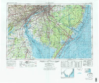
1972 Map of Wilmington
USGS Topo · Published 1976About this map
Wilmington, Philadelphia, and Camden form a dense urban corridor at the center of this 1970s study, connected by monumental crossings like the Benjamin Franklin Bridge and the Delaware Memorial Bridge. The map details the intricate industrial and maritime landscape of the Delaware River as it opens into Delaware Bay, where bathymetric contours track depth gradients past Brandywine Shoal and Miah Maull Shoal. This regional view captures the high-speed transit era, dominated by the New Jersey Turnpike and Garden State Parkway, while preserving traces of colonial history through sites like Old Swedes Church and Old Drawyers Church.
Find a feature on this map
352 named features on this map. Tap any name to fly to it.
Don’t see what you’re looking for? This feature index may not catch every label — zoom into the map to look around manually.
Map Details
Editions of this 1972 Wilmington Map
2 editions found
Other maps of this area

1884 · Sea Isle
USGS Topo · 1:62,500

1884 · Whitings
USGS Topo · 1:62,500

1887 · Atlantic City
USGS Topo · 1:62,500

1888 · Bordentown
USGS Topo · 1:62,500

1888 · Pemberton
USGS Topo · 1:62,500

1888 · Barnegat
USGS Topo · 1:62,500

1888 · Cape May
USGS Topo · 1:62,500

1888 · Dennisville
USGS Topo · 1:62,500

1888 · Little Egg Harbor
USGS Topo · 1:62,500

1888 · Mount Holly
USGS Topo · 1:62,500