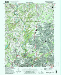
1997 Map of Wilmington North
USGS Topo · Published 2000About this map
Brandywine Creek meanders through the heart of this landscape, serving as a historic and geographical spine that connects the northern reaches of Wilmington with the rolling terrain of southeastern Pennsylvania. The map captures a region defined by its deep cultural institutions and preserved spaces, including the expansive Winterthur Museum and Gardens and the northern tip of Brandywine Battlefield State Park. The density of educational and medical facilities, such as the Alfred I duPont Institute and Alexis I DuPont High Sch, illustrates the late-20th-century suburban development of New Castle County.
Find a feature on this map
139 named features on this map. Tap any name to fly to it.
Don’t see what you’re looking for? This feature index may not catch every label — zoom into the map to look around manually.
Map Details
Editions of this 1997 Wilmington North Map
This is the sole edition of this map. No revisions or reprints were ever made.
Other maps of this area

1890 · Salem
USGS Topo · 1:62,500

1894 · Chester
USGS Topo · 1:62,500

1896 · Chester
USGS Topo · 1:62,500

1898 · Salem
USGS Topo · 1:62,500

1898 · Chester
USGS Topo · 1:62,500

1901 · Camden
USGS Topo · 1:125,000

1901 · West Chester
USGS Topo · 1:62,500

1904 · West Chester
USGS Topo · 1:62,500

1904 · Wilmington
USGS Topo · 1:62,500

1906 · Wilmington
USGS Topo · 1:62,500