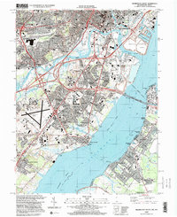
1997 Map of Wilmington South
USGS Topo · Published 2000About this map
Industrial and maritime activity along the Delaware River defines this late-century landscape where the Christina River and Brandywine Creek converge. The Port of Wilmington and its associated Marine Terminal dominate the shoreline, while the massive Delaware Memorial Bridge provides a critical crossing into New Jersey near Deepwater Point. This era shows a densely developed corridor stretching from Wilmington southward through residential enclaves like Minquadale and Holloway Terrace toward the historic community of New Castle. West of the river, the New Castle County Airport anchors a complex network of highways and Conrail rail lines. Across the water, the Supawna Meadows National Wildlife Refuge offers a sharp contrast, preserving the marshlands of the New Castle Flats as they appeared before extensive regional urbanization.
Find a feature on this map
99 named features on this map. Tap any name to fly to it.
Don’t see what you’re looking for? This feature index may not catch every label — zoom into the map to look around manually.
Map Details
Editions of this 1997 Wilmington South Map
This is the sole edition of this map. No revisions or reprints were ever made.
Other maps of this area

1890 · Salem
USGS Topo · 1:62,500

1894 · Chester
USGS Topo · 1:62,500

1896 · Chester
USGS Topo · 1:62,500

1898 · Salem
USGS Topo · 1:62,500

1898 · Chester
USGS Topo · 1:62,500

1901 · Camden
USGS Topo · 1:125,000

1901 · West Chester
USGS Topo · 1:62,500

1904 · West Chester
USGS Topo · 1:62,500

1904 · Wilmington
USGS Topo · 1:62,500

1906 · Wilmington
USGS Topo · 1:62,500