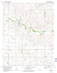
1980 Map of Wilmore
USGS Topo · Published 1980About this map
Wilmore serves as the central hub of this Kansas landscape, situated where the Atchison Topeka and Santa Fe railroad crosses Mule Creek. The town is characterized by its organized street grid and proximity to the Township Cem and several Gravel Pits. Local industry is evidenced by the extensive Oil and Gas Field operations spreading across the western sections, while the eastern terrain transitions into the distinct valleys of Powell Hollow and Snooks Hollow.
Find a feature on this map
19 named features on this map. Tap any name to fly to it.
Don’t see what you’re looking for? This feature index may not catch every label — zoom into the map to look around manually.
Map Details
Editions of this 1980 Wilmore Map
This is the sole edition of this map. No revisions or reprints were ever made.
Other maps of this area

1892 · Coldwater
USGS Topo · 1:125,000

1955 · Pratt
USGS Topo · 1:250,000

1959 · Pratt
USGS Topo · 1:250,000

1968 · Wilmore SE
USGS Topo · 1:24,000

1968 · Belvidere
USGS Topo · 1:24,000

1979 · Coldwater
USGS Topo · 1:24,000

1979 · Protection NE
USGS Topo · 1:24,000
1980 · Nescatunga Creek North
USGS Topo · 1:24,000
1980 · Coldwater NE
USGS Topo · 1:24,000
1980 · Iron Mountain
USGS Topo · 1:24,000