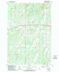
1989 Map of Wilson
USGS Topo · Published 1989About this map
The Hannahville Indian Community and the Escanaba River State Forest dominate this landscape in Menominee County, reflecting a history of forest management and tribal land tenure. Settled life centers on the Chicago and North Western railroad line, which runs east-to-west through the small communities of Wilson, Houle, and Indiantown. These rail-side settlements provide a clear view of the area's development during the late twentieth century, anchored by local institutions like Zion Ch and the Harris Cem.
Find a feature on this map
28 named features on this map. Tap any name to fly to it.
Don’t see what you’re looking for? This feature index may not catch every label — zoom into the map to look around manually.
Map Details
Editions of this 1989 Wilson Map
This is the sole edition of this map. No revisions or reprints were ever made.
Other maps of this area

1932 · Bark River NE
USGS Topo · 1:31,680

1932 · Whitney SE
USGS Topo · 1:31,680

1954 · Escanaba
USGS Topo · 1:250,000

1956 · Foster City
USGS Topo · 1:62,500

1957 · Escanaba
USGS Topo · 1:250,000

1958 · Escanaba
USGS Topo · 1:250,000

1963 · Bark River
USGS Topo · 1:62,500

1963 · Powers
USGS Topo · 1:62,500

1963 · Schaffer
USGS Topo · 1:62,500

1982 · Escanaba
USGS Topo · 1:100,000