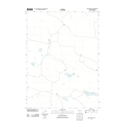
2011 Map of Wilson Valley
USGS Topo · Published 2011About this map
Wilson Valley characterizes this stretch of the Nebraska Sandhills, where a network of family-owned ranching operations defines the local geography. The landscape is punctuated by a series of significant water bodies, including Rat Lake in the west and the neighboring Skull Lake and Little Skull Lake to the southeast. These natural features provided essential water sources for the cattle industry that has long sustained Cherry County. The spatial distribution of the Schleuter Ranch, Hoef- Scheer Ranch, and Higgins Ranch suggests a traditional ranching economy where large parcels of land are centered around localized homesteads. Roadways connect these scattered outposts, such as the Shaul Ranch and Burley Ranch, weaving through the valley floor and across the low-lying terrain. This 2011 survey records the continued presence of established agricultural estates like the Scheer Ranch and Broad Ranch, illustrating the enduring nature of Nebraska's rural land-use patterns into the twenty-first century.
Find a feature on this map
11 named features on this map. Tap any name to fly to it.
Don’t see what you’re looking for? This feature index may not catch every label — zoom into the map to look around manually.
Map Details
Editions of this 2011 Wilson Valley Map
This is the sole edition of this map. No revisions or reprints were ever made.
Other maps of this area

1949 · Long Lake
USGS Topo · 1:62,500

1950 · Wood Lake
USGS Topo · 1:62,500

1950 · Arabia
USGS Topo · 1:62,500

1951 · Long Lake
USGS Topo · 1:62,500

1951 · Moon Lake
USGS Topo · 1:62,500

1957 · Valentine
USGS Topo · 1:250,000

1959 · Valentine
USGS Topo · 1:250,000

1985 · Long Lake
USGS Topo · 1:24,000

1985 · Wilson Valley
USGS Topo · 1:24,000
1985 · Brush Creek
USGS Topo · 1:24,000