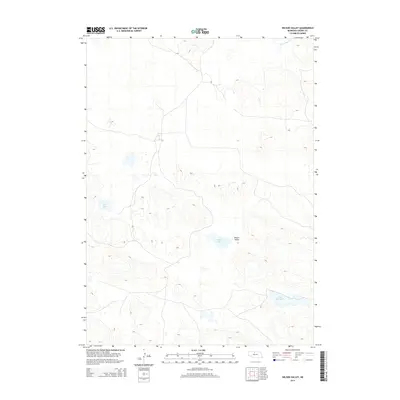
2014 Map of Wilson Valley
USGS Topo · Published 2014About this map
Wilson Valley defines the core of this landscape, a remote section of Cherry County characterized by a sparse network of prairie roads and scattered water bodies. The topography is dominated by the intricate depressions and rises typical of the Nebraska Sandhills, where drainage is limited to features such as the S Fork Plum Cr in the northeast and a series of distinct basins. These basins host several named lakes including Rat Lake, Skull Lake, and Little Skull Lake, which provide critical reference points in an otherwise repeating terrain of dunes and hollows. The 2014 survey by the U.S. Geological Survey captures the area in its contemporary state, showing the minimal human footprint of ranch roads and fenced boundaries that navigate the undulating ground between these isolated water sources.
Find a feature on this map
5 named features on this map. Tap any name to fly to it.
Don’t see what you’re looking for? This feature index may not catch every label — zoom into the map to look around manually.
Map Details
Editions of this 2014 Wilson Valley Map
This is the sole edition of this map. No revisions or reprints were ever made.
Other maps of this area

1949 · Long Lake
USGS Topo · 1:62,500

1950 · Wood Lake
USGS Topo · 1:62,500

1950 · Arabia
USGS Topo · 1:62,500

1951 · Long Lake
USGS Topo · 1:62,500

1951 · Moon Lake
USGS Topo · 1:62,500

1957 · Valentine
USGS Topo · 1:250,000

1959 · Valentine
USGS Topo · 1:250,000

1985 · Long Lake
USGS Topo · 1:24,000

1985 · Wilson Valley
USGS Topo · 1:24,000
1985 · Brush Creek
USGS Topo · 1:24,000