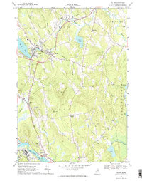
1968 Map of Wilton
USGS Topo · Published 1971About this map
Wilson Stream and the Central Maine Railroad corridor define the industrial and agricultural landscape of Franklin County in the late 1960s. The village of Wilton serves as a central hub, flanked by the residential and recreational waters of Wilson Pond and Pease Pond. Moving south through the hills, the terrain transitions into the industrial works of North Jay, where several quarries and gravel pits underscore the area's geological economy. Along the Androscoggin River at Jay and Riley, the map records specialized infrastructure such as a drive-in theater and an industrial waste pond, reflecting the mid-century intersection of community leisure and manufacturing. Numerous family-named crossroads like Beans Corner, Kennedys Corners, and Stones Corner provide critical landmarks for genealogists tracking local landholdings across the townships of Wilton, Jay, and Chesterville.
Find a feature on this map
50 named features on this map. Tap any name to fly to it.
Don’t see what you’re looking for? This feature index may not catch every label — zoom into the map to look around manually.
Map Details
Editions of this 1968 Wilton Map
This is the sole edition of this map. No revisions or reprints were ever made.
Other maps of this area

1910 · Livermore
USGS Topo · 1:62,500

1911 · Buckfield
USGS Topo · 1:62,500

1912 · Livermore
USGS Topo · 1:62,500

1913 · Buckfield
USGS Topo · 1:62,500

1924 · Farmington
USGS Topo · 1:62,500

1926 · Dixfield
USGS Topo · 1:62,500

1929 · Dixfield
USGS Topo · 1:62,500

1941 · Livermore
USGS Topo · 1:62,500

1942 · Buckfield
USGS Topo · 1:62,500

1950 · Lewiston
USGS Topo · 1:250,000