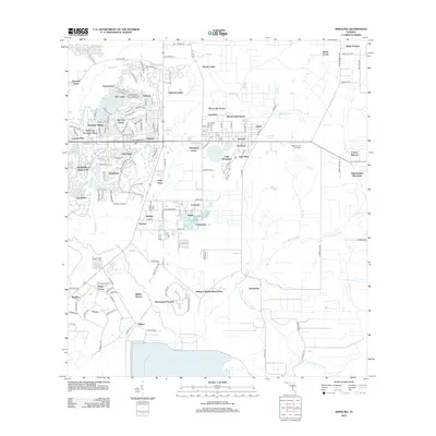
2012 Map of Wimauma
USGS Topo · Published 2012About this map
Sun City Center and its surrounding residential developments define the suburban landscape of southern Hillsborough County on this 2012 survey. This era shows a complex network of planned communities, including The Knolls of Kings Point and Valencia Lakes, characterized by dense residential streets and artificial water features. To the east, the map captures the community of Wimauma, anchored by Lake Wimauma and the Wimauma Air Park. The southern portion of the quadrangle is dominated by the winding course of the Little Manatee River, where the landscape transitions toward larger land holdings and conservation areas like Riverranch Preserve. Historically significant agricultural pockets like Sweat Farms and Balm Gardens persist near the more developed corridors, illustrating the ongoing conversion of Florida ranch and farm lands into managed residential estates.
Find a feature on this map
149 named features on this map. Tap any name to fly to it.
Don’t see what you’re looking for? This feature index may not catch every label — zoom into the map to look around manually.
Map Details
Editions of this 2012 Wimauma Map
This is the sole edition of this map. No revisions or reprints were ever made.
Other maps of this area

1921 · Tampa
USGS Topo · 1:62,500

1944 · Ruskin
USGS Topo · 1:31,680

1944 · Rye
USGS Topo · 1:31,680

1944 · Wimauma
USGS Topo · 1:31,680

1944 · Parish
USGS Topo · 1:31,680

1944 · Balm
USGS Topo · 1:31,680

1945 · Gadsden Point
USGS Topo · 1:31,680

1947 · Ruskin
USGS Topo · 1:25,000

1947 · Wimauma
USGS Topo · 1:25,000
1947 · Gadsden Point
USGS Topo · 1:25,000