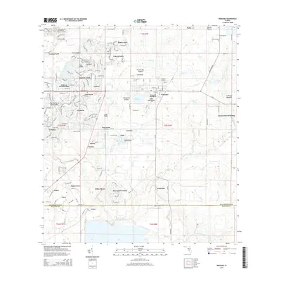
2015 Map of Wimauma
USGS Topo · Published 2015About this map
Wimauma and the neighboring planned community of Sun City Center define the landscape of south-central Hillsborough County in the mid-2010s. The area shows a distinct contrast between the established grid of Wimauma and the winding residential networks of retirement developments like Valencia Lakes, Caloosa, and The Knolls of Kings Point. The expansion of these residential clusters sits alongside agricultural operations such as West Lake Farms and Ranch Lands, illustrating the ongoing transformation of Florida's rural interior.
Find a feature on this map
53 named features on this map. Tap any name to fly to it.
Don’t see what you’re looking for? This feature index may not catch every label — zoom into the map to look around manually.
Map Details
Editions of this 2015 Wimauma Map
This is the sole edition of this map. No revisions or reprints were ever made.
Other maps of this area

1921 · Tampa
USGS Topo · 1:62,500

1944 · Ruskin
USGS Topo · 1:31,680

1944 · Rye
USGS Topo · 1:31,680

1944 · Wimauma
USGS Topo · 1:31,680

1944 · Parish
USGS Topo · 1:31,680

1944 · Balm
USGS Topo · 1:31,680

1945 · Gadsden Point
USGS Topo · 1:31,680

1947 · Ruskin
USGS Topo · 1:25,000

1947 · Wimauma
USGS Topo · 1:25,000
1947 · Gadsden Point
USGS Topo · 1:25,000