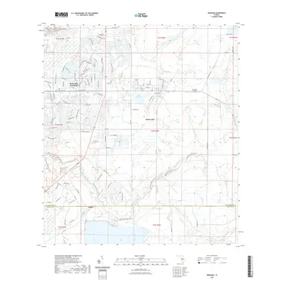
2021 Map of Wimauma
USGS Topo · Published 2021About this map
Sun City Center and Wimauma stand as the primary population centers in this 2021 landscape, illustrating the distinct contrast between planned residential developments and older rural settlements. The map details a sophisticated network of residential streets such as Emerald Lake Dr and S Pebble Beach Blvd, which interface with the natural drainage systems of Cypress Creek and Bullfrog Cr. To the south, the terrain transitions into a more riparian environment defined by the Little Manatee River and its S Fork Little Manatee River. This area includes the small settlement of Willow near the border of Hillsborough and Manatee counties. The presence of Lake Wimauma and the Wimauma Air Park highlights the varied land use of the region, ranging from water resources to local aviation infrastructure.
Find a feature on this map
107 named features on this map. Tap any name to fly to it.
Don’t see what you’re looking for? This feature index may not catch every label — zoom into the map to look around manually.
Map Details
Editions of this 2021 Wimauma Map
This is the sole edition of this map. No revisions or reprints were ever made.
Other maps of this area

1921 · Tampa
USGS Topo · 1:62,500

1944 · Ruskin
USGS Topo · 1:31,680

1944 · Rye
USGS Topo · 1:31,680

1944 · Wimauma
USGS Topo · 1:31,680

1944 · Parish
USGS Topo · 1:31,680

1944 · Balm
USGS Topo · 1:31,680

1945 · Gadsden Point
USGS Topo · 1:31,680

1947 · Ruskin
USGS Topo · 1:25,000

1947 · Wimauma
USGS Topo · 1:25,000
1947 · Gadsden Point
USGS Topo · 1:25,000