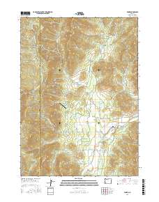
2017 Map of Wimer
USGS Topo · Published 2017About this map
Evans Valley and the community of Wimer anchor this topographic view of the Southern Oregon interior, where the landscape is defined by the complex drainage of Evans Creek and its many named gulches. The terrain rises sharply toward Elk Mtn and the Josephine County line, punctuated by strategic passes such as China Gap and Coker Gap. This 2017 study illustrates a sophisticated network of water management and rural infrastructure, from the early-century irrigation legacy of the Vroman Ditch and Red Ditch to the presence of Springbrook Airport. The map traces a myriad of secondary routes including Queens Branch Rd and Battle Mountain Fire Rd, revealing how contemporary roads follow the natural contours of the gulches, such as French Gulch and Bummer Gulch, which have long shaped the local economy and settlement patterns.
Find a feature on this map
58 named features on this map. Tap any name to fly to it.
Don’t see what you’re looking for? This feature index may not catch every label — zoom into the map to look around manually.
Map Details
Editions of this 2017 Wimer Map
This is the sole edition of this map. No revisions or reprints were ever made.
Other maps of this area

1904 · Riddle
USGS Topo · 1:125,000

1908 · Grants Pass
USGS Topo · 1:125,000

1954 · Glendale
USGS Topo · 1:62,500

1954 · Gold Hill
USGS Topo · 1:62,500

1954 · Wimer
USGS Topo · 1:62,500

1954 · Grants Pass
USGS Topo · 1:62,500

1955 · Medford
USGS Topo · 1:250,000

1957 · Medford
USGS Topo · 1:250,000

1958 · Medford
USGS Topo · 1:250,000
1974 · Grants Pass NE
USGS Topo · 1:24,000