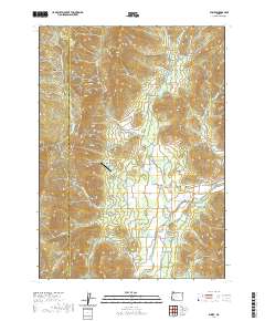
2020 Map of Wimer
USGS Topo · Published 2020About this map
Wimer and the neighboring settlements of Pleasant Valley and Evans Valley anchor this landscape along the winding course of Evans Creek. The terrain is defined by a dense network of gulches and ridges, including French Gulch and Harris Gulch to the north, and Greens Gulch near the community center. Agricultural and water management history is evident through features like Yeoman Ditch and Red Ditch, alongside several small impoundments such as Jackson Reservoir and Badcock Reservoir.
Find a feature on this map
57 named features on this map. Tap any name to fly to it.
Don’t see what you’re looking for? This feature index may not catch every label — zoom into the map to look around manually.
Map Details
Editions of this 2020 Wimer Map
This is the sole edition of this map. No revisions or reprints were ever made.
Other maps of this area

1904 · Riddle
USGS Topo · 1:125,000

1908 · Grants Pass
USGS Topo · 1:125,000

1954 · Glendale
USGS Topo · 1:62,500

1954 · Gold Hill
USGS Topo · 1:62,500

1954 · Wimer
USGS Topo · 1:62,500

1954 · Grants Pass
USGS Topo · 1:62,500

1955 · Medford
USGS Topo · 1:250,000

1957 · Medford
USGS Topo · 1:250,000

1958 · Medford
USGS Topo · 1:250,000
1974 · Grants Pass NE
USGS Topo · 1:24,000