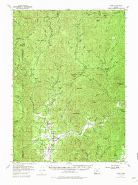
1954 Map of Wimer
USGS Topo · Published 1983About this map
Wimer serves as the primary hub of this valley landscape, where the confluence of several prominent drainages shaped early settlement in Southern Oregon. The map documents the mid-century rural infrastructure of the Evans Valley, notably featuring the Evans Valley Sch and small community clusters like Branch and Trimble. This area is defined by its network of creeks and gulches, including the notable Jumpoff Joe Creek and the meandering Grave Creek, which flows through the northwestern corner of the quadrangle. High-elevation points like King Mtn and Battle Mtn frame the valley floors. The presence of the Salt Creek Guard Sta and Pleasant Creek Guard Station reflects the historical management of the Umpqua National Forest lands that extend across the northern reaches of the map.
Find a feature on this map
84 named features on this map. Tap any name to fly to it.
Don’t see what you’re looking for? This feature index may not catch every label — zoom into the map to look around manually.
Map Details
Editions of this 1954 Wimer Map
3 editions found

Other maps of this area

1891 · Ashland
USGS Topo · 1:250,000

1893 · Ashland
USGS Topo · 1:250,000

1897 · Ashland
USGS Topo · 1:250,000

1904 · Riddle
USGS Topo · 1:125,000

1908 · Grants Pass
USGS Topo · 1:125,000

1938 · Medford
USGS Topo · 1:125,000

1943 · Trail
USGS Topo · 1:62,500

1944 · Tiller
USGS Topo · 1:62,500

1954 · Medford
USGS Topo · 1:62,500

1954 · Days Creek
USGS Topo · 1:62,500