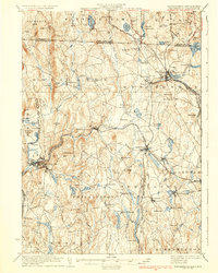
1935 Map of Winchendon
USGS Topo · Published 1935About this map
The Miller River serves as the industrial and topographic spine of this region, carving a path through the hills that the Fitchburg Railroad follows to connect manufacturing hubs like Athol and Winchendon. This mid-1930s landscape is defined by the proximity of the New Hampshire and Massachusetts border, where many small settlements such as Hydeville and Waterville grew around water-powered mill sites. The prevalence of named hills like Tully Mtn and Benjamin Hill among numerous small ponds suggests a territory where agriculture and timber remained vital alongside the burgeoning rail-side industries.
Find a feature on this map
110 named features on this map. Tap any name to fly to it.
Don’t see what you’re looking for? This feature index may not catch every label — zoom into the map to look around manually.
Map Details
Editions of this 1935 Winchendon Map
4 editions found
Other maps of this area

1885 · Worcester
USGS Topo · 1:62,500

1886 · Worcester
USGS Topo · 1:62,500

1887 · Warwick
USGS Topo · 1:62,500

1887 · Belchertown
USGS Topo · 1:62,500

1887 · Winchendon
USGS Topo · 1:62,500

1887 · Barre
USGS Topo · 1:62,500

1887 · Fitchburg
USGS Topo · 1:62,500

1889 · Fitchburg
USGS Topo · 1:62,500

1889 · Barre
USGS Topo · 1:62,500

1889 · Warwick
USGS Topo · 1:62,500