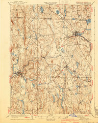
1935 Map of Winchendon
USGS Topo · Published 1940About this map
The industrial and rail-oriented landscape of the New Hampshire Massachusetts border is defined by the convergence of several major railroad lines in the 1930s. The Fitchburg Railroad and the Boston and Albany Railroad dominate the corridors through Winchendon and Baldwinville, illustrating the era's reliance on rail transport for both manufacturing centers and the timber industry. Numerous small settlements like Hydeville, Waterville, and Pequoig Station appear alongside significant water bodies such as Lake Monomonac and Sip Pond. The topography of the Monadnock region is evident in the cluster of elevations including Tully Mtn and Mt Pleasant, while local history is preserved in the location of School No 1, the Rand Cem, and several named hills that likely represent early family farmsteads and rural neighborhoods.
Find a feature on this map
108 named features on this map. Tap any name to fly to it.
Don’t see what you’re looking for? This feature index may not catch every label — zoom into the map to look around manually.
Map Details
Editions of this 1935 Winchendon Map
4 editions found
Other maps of this area

1885 · Worcester
USGS Topo · 1:62,500

1886 · Worcester
USGS Topo · 1:62,500

1887 · Warwick
USGS Topo · 1:62,500

1887 · Belchertown
USGS Topo · 1:62,500

1887 · Winchendon
USGS Topo · 1:62,500

1887 · Barre
USGS Topo · 1:62,500

1887 · Fitchburg
USGS Topo · 1:62,500

1889 · Fitchburg
USGS Topo · 1:62,500

1889 · Barre
USGS Topo · 1:62,500

1889 · Warwick
USGS Topo · 1:62,500