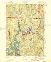
1946 Map of Winchendon
USGS Topo · Published 1946About this map
Winchendon serves as the industrial and civic anchor of this mid-1940s landscape, situated where the Boston and Maine railroad intersects the flow of the Millers River. This survey captures the region's complex water-powered heritage, with numerous mill ponds and reservoirs like Whitney Pond and Whites Mill Pond supporting a cluster of satellite industrial hamlets including Winchendon Springs, Waterville, and Bullardville.
Find a feature on this map
68 named features on this map. Tap any name to fly to it.
Don’t see what you’re looking for? This feature index may not catch every label — zoom into the map to look around manually.
Map Details
Editions of this 1946 Winchendon Map
2 editions found
Other maps of this area

1887 · Winchendon
USGS Topo · 1:62,500

1887 · Fitchburg
USGS Topo · 1:62,500

1889 · Fitchburg
USGS Topo · 1:62,500

1890 · Winchendon
USGS Topo · 1:62,500

1893 · Fitchburg
USGS Topo · 1:62,500

1894 · Winchendon
USGS Topo · 1:62,500

1898 · Monadnock
USGS Topo · 1:62,500

1900 · Peterboro
USGS Topo · 1:62,500

1931 · Fitchburg
USGS Topo · 1:48,000

1932 · Winchendon
USGS Topo · 1:48,000