
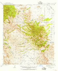
1943 Map of Winchester Mts.
USGS Topo · Published 1945About this map
Winchester Mountains and the surrounding high desert terrain dominate this mid-century survey of southeastern Arizona. The landscape is defined by its water sources, with numerous sites like Hooker Hot Springs, Mud Springs, and Riggs Seep anchoring the local geography. Large cattle operations are the primary sign of human activity during this era, with several family-named outfits scattered across the basin and range, including Wear Ranch, Lee Ranch, and the Petite Hooker Ranch. To the east, the map captures the transition into the Sulphur Spring Valley, while the western edge reaches the Galiuro Mountains. The rugged interior is carved by a network of drainage systems such as Bear Creek and Javelina Canyon, while high peaks like Reiley Peak and Muskhog Mtn provide prominent landmarks within the Coronado National Forest.
Find a feature on this map
52 named features on this map. Tap any name to fly to it.
Don’t see what you’re looking for? This feature index may not catch every label — zoom into the map to look around manually.
Map Details
Editions of this 1943 Winchester Mts. Map
2 editions found
Other maps of this area

1922 · Willcox
USGS Topo · 1:125,000

1938 · Galiuro Mts
USGS Topo · 1:48,000

1940 · Sierra Bonita Ranch
USGS Topo · 1:62,500

1942 · Sierra Bonita Ranch
USGS Topo · 1:62,500

1942 · Mt. Graham
USGS Topo · 1:62,500

1943 · Willcox
USGS Topo · 1:62,500

1943 · Galiuro Mts
USGS Topo · 1:62,500

1943 · Cochise
USGS Topo · 1:62,500

1943 · Dragoon
USGS Topo · 1:62,500

1943 · Sierra Bonita Ranch
USGS Topo · 1:62,500