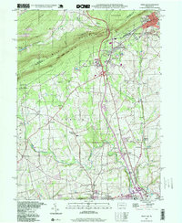
1997 Map of Wind Gap
USGS Topo · Published 1999About this map
The Blue Mountain ridge dominates the northern horizon of this Northampton County landscape, providing a dramatic backdrop for the industrial and agricultural valleys below. By the late 1990s, the region shows a complex intersection of recreation and industry, where the Appalachian Trail follows the heights of Ross Mountain while the lowlands are pockmarked with numerous Quarries. The rail infrastructure, including the Pen Argyl Yards and several Abandoned lines, speaks to a heritage of heavy transport that once connected the slate and mineral deposits of West Pen Argyl and Wind Gap to wider markets. Scattered across the Bushkill and Plainfield townships are the small centers of local life, from the Mt View Park Racetrack to country institutions like St Peters Union Ch and Township Sch. Natural conservation is evident in the sprawling State Game Lands No 168 and the protected acres of Jacobsburg State Park.
Find a feature on this map
66 named features on this map. Tap any name to fly to it.
Don’t see what you’re looking for? This feature index may not catch every label — zoom into the map to look around manually.
Map Details
Editions of this 1997 Wind Gap Map
This is the sole edition of this map. No revisions or reprints were ever made.
Other maps of this area

1890 · Easton
USGS Topo · 1:62,500

1891 · Easton
USGS Topo · 1:62,500

1891 · Delaware Water Gap
USGS Topo · 1:62,500

1893 · Delaware Water Gap
USGS Topo · 1:62,500

1894 · Allentown
USGS Topo · 1:62,500

1914 · Wind Gap
USGS Topo · 1:62,500

1916 · Wind Gap
USGS Topo · 1:62,500

1932 · Easton
USGS Topo · 1:62,500

1936 · Delaware Water Gap
USGS Topo · 1:48,000

1939 · Allentown
USGS Topo · 1:62,500
Featured Places
- Pen Argyl, PA
- Wind Gap, PA
- Bushkill Township, PA
- Rismiller, Bushkill Township
- Wardsburg, Plainfield Township