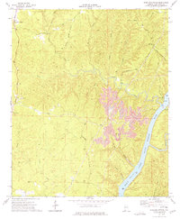
1974 Map of Windham Springs
USGS Topo · Published 1976About this map
Windham Springs serves as a primary settlement point in this north-central Alabama landscape, situated among a complex network of creeks and rising ridge lines. The 1970s terrain is heavily marked by industrial activity, most notably a massive Strip Mine that dominates the central portion of the quadrangle, altering the natural contours near the Panther Branch. To the south and east, the Black Warrior River widens into Holt Lake, where recreation facilities like the Blue Creek Public Use Area and a Boat Ramp appear along the shoreline.
Find a feature on this map
32 named features on this map. Tap any name to fly to it.
Don’t see what you’re looking for? This feature index may not catch every label — zoom into the map to look around manually.
Map Details
Editions of this 1974 Windham Springs Map
This is the sole edition of this map. No revisions or reprints were ever made.
Other maps of this area

1893 · Jasper
USGS Topo · 1:125,000

1899 · Brookwood
USGS Topo · 1:125,000

1926 · Samantha
USGS Topo · 1:48,000

1928 · Samantha
USGS Topo · 1:62,500

1929 · Searles
USGS Topo · 1:48,000

1934 · Searles
USGS Topo · 1:62,500

1949 · Tutwiler School
USGS Topo · 1:24,000

1949 · Wiley
USGS Topo · 1:24,000
1951 · Tutwiler School
USGS Topo · 1:24,000

1951 · Wiley
USGS Topo · 1:24,000