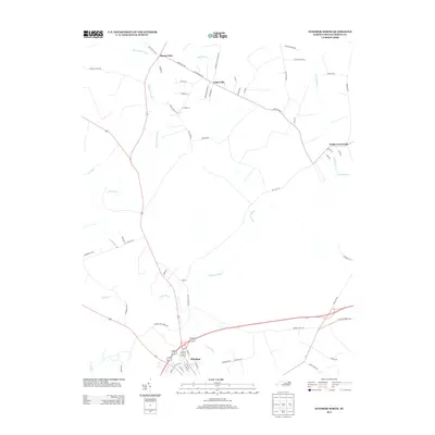
2013 Map of Windsor North
USGS Topo · Published 2013About this map
The Cashie River meanders through the heart of this North Carolina coastal plain landscape, defining the geography of southern Bertie County. Near the southern edge of the sheet, the county seat of Windsor serves as a focal point where multiple roads and waterways converge. The terrain is characterized by a complex network of wetlands and drainage systems, including Whiteoak Swamp, Hoggard Mill Cr, and Chiska Cr, which suggest a long history of timber and agricultural land use. Moving north, the map reveals smaller settlements like Askewville and Buena Vista, along with rural junctions such as Todds Crossroads. Numerous family-named roads, such as Mizelle Ln and Jesse Hoggard Rd, reflect the deep genealogical roots of the local community, providing valuable reference points for researchers tracing property lines and ancestral homesteads in this part of the Inner Banks region.
Find a feature on this map
61 named features on this map. Tap any name to fly to it.
Don’t see what you’re looking for? This feature index may not catch every label — zoom into the map to look around manually.
Map Details
Editions of this 2013 Windsor North Map
This is the sole edition of this map. No revisions or reprints were ever made.
Other maps of this area

1901 · Williamston
USGS Topo · 1:62,500

1902 · Williamston
USGS Topo · 1:62,500

1943 · Plymouth
USGS Topo · 1:125,000

1953 · Norfolk
USGS Topo · 1:250,000

1953 · Rocky Mount
USGS Topo · 1:250,000

1954 · Rocky Mount
USGS Topo · 1:250,000

1972 · Republican
USGS Topo · 1:24,000

1972 · Aulander
USGS Topo · 1:24,000

1978 · Windsor South
USGS Topo · 1:24,000
1979 · Woodard
USGS Topo · 1:24,000