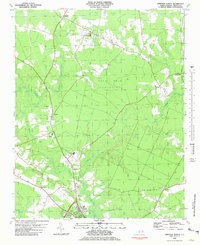
1981 Map of Windsor North
USGS Topo · Published 1981About this map
Windsor and its northern surroundings in Bertie County are defined by the winding course of the Cashie River and its numerous tributaries. In the early 1980s, the landscape remained largely rural, characterized by the expansive wetlands of the Pell Mell Pocosin and drainage networks including Hoggard Mill Creek and Chiska Creek. The settlement pattern centers on small communities and crossroads such as Askewville, Buena Vista, and Todds Crossroads, connected by a network of local roads that largely follow the natural rises in the terrain. For local historians, the map documents a high density of rural institutions, including Cedar Fork Ch, Ross Ch, and Bethel Ch, alongside several family cemeteries and a Lookout Tower. Evidence of the area's industrial past is visible in an Old Railroad Grade and scattered sandpits, while the presence of Bertie High Sch and Davis Park marks the modern community infrastructure of the period.
Find a feature on this map
28 named features on this map. Tap any name to fly to it.
Don’t see what you’re looking for? This feature index may not catch every label — zoom into the map to look around manually.
Map Details
Editions of this 1981 Windsor North Map
This is the sole edition of this map. No revisions or reprints were ever made.
Other maps of this area

1901 · Williamston
USGS Topo · 1:62,500

1902 · Williamston
USGS Topo · 1:62,500

1943 · Plymouth
USGS Topo · 1:125,000

1953 · Norfolk
USGS Topo · 1:250,000

1953 · Rocky Mount
USGS Topo · 1:250,000

1954 · Rocky Mount
USGS Topo · 1:250,000

1972 · Republican
USGS Topo · 1:24,000

1972 · Aulander
USGS Topo · 1:24,000

1978 · Windsor South
USGS Topo · 1:24,000
1979 · Woodard
USGS Topo · 1:24,000