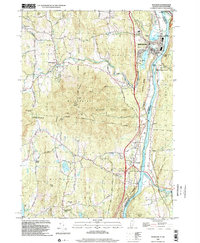
1998 Map of Windsor
USGS Topo · Published 2002About this map
The Connecticut River serves as the primary artery of this Upper Valley region, defining the border between Windsor, Vermont, and New Hampshire. The terrain is dominated by the massive profile of Mt Ascutney, around which Ascutney State Park and several wildlife management areas are established. Settlement patterns follow the valley floors and drainage of Mill Brook, where the village of Brownsville and the town center of Windsor developed around water power and transport routes.
Find a feature on this map
60 named features on this map. Tap any name to fly to it.
Don’t see what you’re looking for? This feature index may not catch every label — zoom into the map to look around manually.
Map Details
Editions of this 1998 Windsor Map
This is the sole edition of this map. No revisions or reprints were ever made.
Other maps of this area

1906 · Hanover
USGS Topo · 1:62,500

1908 · Hanover
USGS Topo · 1:62,500

1911 · Woodstock
USGS Topo · 1:62,500

1913 · Woodstock
USGS Topo · 1:62,500

1926 · Claremont
USGS Topo · 1:62,500

1928 · Ludlow
USGS Topo · 1:48,000

1929 · Claremont
USGS Topo · 1:62,500

1929 · Ludlow
USGS Topo · 1:62,500

1932 · Ludlow
USGS Topo · 1:62,500

1943 · Woodstock
USGS Topo · 1:62,500