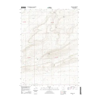
2015 Map of Windy Hill
USGS Topo · Published 2015About this map
Freezeout Mountains dominate the central topography of this Carbon County landscape, where high ridges and deep draws dictate the local drainage patterns. The south is defined by the course of the Medicine Bow River and the adjacent Medicine Bow Rd, which follows the river's path across the lower elevations. The map reveals an area defined by distinct landforms such as Windy Hill and Smith Creek Rim, which overlook a network of seasonal watercourses including Sledge Cr and Willow Spring Cr. The presence of features like Petes Gap and Shearing Pen Draw points toward a history of livestock movement through the breaks in the mountains. This 2015 survey provides a contemporary view of the region's enduring rural character, illustrating the relationship between the elevated Little Basin and the lower The Hay Slough wetlands.
Find a feature on this map
18 named features on this map. Tap any name to fly to it.
Don’t see what you’re looking for? This feature index may not catch every label — zoom into the map to look around manually.
Map Details
Editions of this 2015 Windy Hill Map
This is the sole edition of this map. No revisions or reprints were ever made.
Other maps of this area

1914 · Saddleback Hills
USGS Topo · 1:62,500

1915 · Como Ridge
USGS Topo · 1:48,000

1918 · Como Ridge
USGS Topo · 1:62,500

1921 · Saddleback Hills
USGS Topo · 1:62,500

1954 · Rawlins
USGS Topo · 1:250,000

1955 · Casper
USGS Topo · 1:250,000

1958 · Rawlins
USGS Topo · 1:250,000

1958 · Casper
USGS Topo · 1:250,000
1961 · Pine Hill
USGS Topo · 1:24,000

1961 · T B Ranch
USGS Topo · 1:24,000