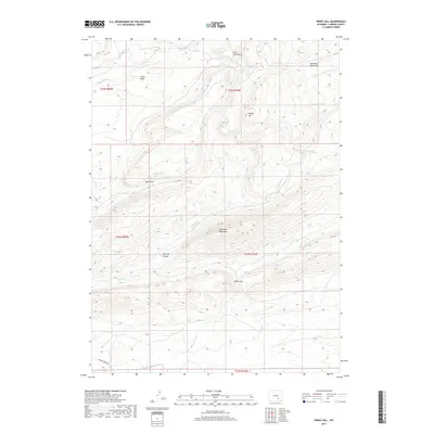
2017 Map of Windy Hill
USGS Topo · Published 2017About this map
The Freezeout Mountains dominate this central Wyoming landscape, creating a high-relief terrain where several drainages originate. The southern edge of the sheet is defined by the winding course of the Medicine Bow River, a critical water source in this arid region. This 2017 survey reveals an environment shaped by complex geological folds and gaps, most notably at Petes Gap and the prominent Windy Hill. The distribution of water features, such as The Hay Slough and various ephemeral draws like Shearing Pen Draw and Red Draw, underscores the seasonal nature of the local hydrography. The map also delineates the Smith Creek Rim and the sheltered Little Basin, reflecting a traditional western ranching landscape where named landmarks often served as vital navigation points for livestock management across the high plains.
Find a feature on this map
18 named features on this map. Tap any name to fly to it.
Don’t see what you’re looking for? This feature index may not catch every label — zoom into the map to look around manually.
Map Details
Editions of this 2017 Windy Hill Map
This is the sole edition of this map. No revisions or reprints were ever made.
Other maps of this area

1914 · Saddleback Hills
USGS Topo · 1:62,500

1915 · Como Ridge
USGS Topo · 1:48,000

1918 · Como Ridge
USGS Topo · 1:62,500

1921 · Saddleback Hills
USGS Topo · 1:62,500

1954 · Rawlins
USGS Topo · 1:250,000

1955 · Casper
USGS Topo · 1:250,000

1958 · Rawlins
USGS Topo · 1:250,000

1958 · Casper
USGS Topo · 1:250,000
1961 · Pine Hill
USGS Topo · 1:24,000

1961 · T B Ranch
USGS Topo · 1:24,000