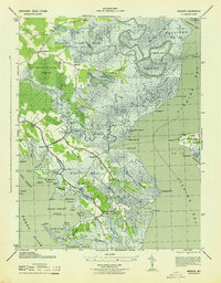
1943 Map of Wingate
USGS Topo · Published 1943About this map
Bishops Head and the fishing community of Elliott occupy the low-lying reaches of southern Dorchester County, where the Chesapeake's reach is felt through a complex network of marshes and tidal guts. This 1943 survey, compiled from air photographs, details a landscape dominated by the Great Marsh and the Straits Marsh, where human settlement is confined to higher ground along roads like Lakes No 5 Straits No 10. In the northern interior, the Beech Ground Swamp and Raccoon Creek Marsh give way to the winding course of the Blackwater River. Significant local landmarks include St Thomas church and the Wingate PO, reflecting the importance of established crossroads for these water-bound communities. The map also documents specific navigational aids and local points of interest such as Wrights Log and the Sugarloaf rise, providing a record of the era's geography before significant coastal erosion or changes in land use occurred.
Find a feature on this map
82 named features on this map. Tap any name to fly to it.
Don’t see what you’re looking for? This feature index may not catch every label — zoom into the map to look around manually.
Map Details
Editions of this 1943 Wingate Map
This is the sole edition of this map. No revisions or reprints were ever made.
Other maps of this area

1898 · St. Marys
USGS Topo · 1:125,000

1903 · Nanticoke
USGS Topo · 1:62,500

1903 · Bloodsworth Island
USGS Topo · 1:62,500

1903 · Deal Island
USGS Topo · 1:62,500

1905 · Crapo
USGS Topo · 1:62,500

1906 · St. Marys
USGS Topo · 1:125,000

1942 · Bloodsworth Island
USGS Topo · 1:24,000

1942 · Richland Point
USGS Topo · 1:24,000
1942 · Honga
USGS Topo · 1:24,000

1942 · Deal Island
USGS Topo · 1:24,000