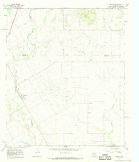
1967 Map of Wingate
USGS Topo · Published 1969About this map
Wingate serves as the primary hub in this West Texas landscape, situated along the winding course of Valley Creek. In the late 1960s, the region's economy was clearly defined by a massive Oil Field and numerous Oil Wells scattered across the rolling terrain. The boundary between Taylor Co Runnels Co cuts through the northern portion of the sheet, where an Indefinite Boundary follows the path of Big Coyote Creek. Genealogists will find particular value in the documentation of smaller rural settlements like Pumphrey and Sliger, along with the Pumphrey Cem. The map's detail also reveals a network of resource extraction sites, including several Gravel Pit locations and larger Gravel Pits that supported the local infrastructure of the era.
Find a feature on this map
15 named features on this map. Tap any name to fly to it.
Don’t see what you’re looking for? This feature index may not catch every label — zoom into the map to look around manually.
Map Details
Editions of this 1967 Wingate Map
This is the sole edition of this map. No revisions or reprints were ever made.
Other maps of this area

1890 · Abilene
USGS Topo · 1:125,000

1891 · Hayrick
USGS Topo · 1:125,000

1892 · Abilene
USGS Topo · 1:125,000

1892 · Ballinger
USGS Topo · 1:125,000

1893 · Sweetwater
USGS Topo · 1:125,000

1894 · Hayrick
USGS Topo · 1:125,000

1954 · Brownwood
USGS Topo · 1:250,000

1954 · Big Spring
USGS Topo · 1:250,000

1954 · Abilene
USGS Topo · 1:250,000

1954 · San Angelo
USGS Topo · 1:250,000