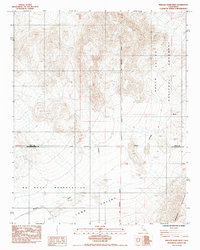
1985 Map of Wingate Wash West
USGS Topo · Published 1985About this map
The Death Valley National Monument dominates the eastern landscape of this mid-1980s topographic study, where the arid terrain meets the Owlshead Mountains. This region serves as a significant intersection of administrative and geographical boundaries, clearly marked by the San Bernardino Meridian and the Naval Reservation Boundary. To the west, the U S Naval Reservation restricts access to vast stretches of high desert. The map captures the natural drainage patterns of the area, most notably the winding path of Wingate Wash as it descends through Long Valley. This provisional edition provides a precise look at the topographical contours and survey lines that defined this portion of the Inyo and San Bernardino County line before modern digital mapping, preserving the specific designation of the monument and military lands as they stood in the early 1980s.
Find a feature on this map
12 named features on this map. Tap any name to fly to it.
Don’t see what you’re looking for? This feature index may not catch every label — zoom into the map to look around manually.
Map Details
Editions of this 1985 Wingate Wash West Map
This is the sole edition of this map. No revisions or reprints were ever made.
Other maps of this area

1915 · Searles Lake
USGS Topo · 1:250,000

1933 · Avawatz Mountains
USGS Topo · 1:250,000

1947 · Trona
USGS Topo · 1:250,000

1948 · Trona
USGS Topo · 1:250,000

1948 · Quail Mountains
USGS Topo · 1:62,500

1950 · Manly Peak
USGS Topo · 1:62,500

1950 · Wingate Wash
USGS Topo · 1:62,500

1950 · Wingate Pass
USGS Topo · 1:62,500

1951 · Wingate Pass
USGS Topo · 1:62,500

1951 · Quail Mountains
USGS Topo · 1:62,500